Wndsn Quadrant Telemeter Tutorials
Making the most out of our graphical telemetry computers.
Like with many complex instruments, there are multiple ways to solve certain problems and to measure the required inputs. Combining the various functions leads to a multitude of advanced uses.
How to Draw Stars on Your Latitude Quadrant
Instrument used: Wndsn Latitude Quadrant
The goal is to calculate the positions to draw a small number of navigational stars on an existing Latitude Quadrant.
- To set the position of a star on the Quadrant, we need the star's declination and culmination date, as well as our latitude
- Example star: SPICA (α Virginis), culmination at midnight: APR-13, declination: -11.3°
- Our latitude: 52.5°
Practical solution[1]
- Subtract the star’s declination from the latitude
- Example:
52.5° - -11.3° = 63.8°
- Example:
- Project the resulting value from the degree scale up to the cosine scale
- Set the cursor to the projected value on the cosine scale
- Rotate the string around the vertex and set the culmination date (APR-13) on the calendar scale
- The cursor marks the position of the star on the Quadrant
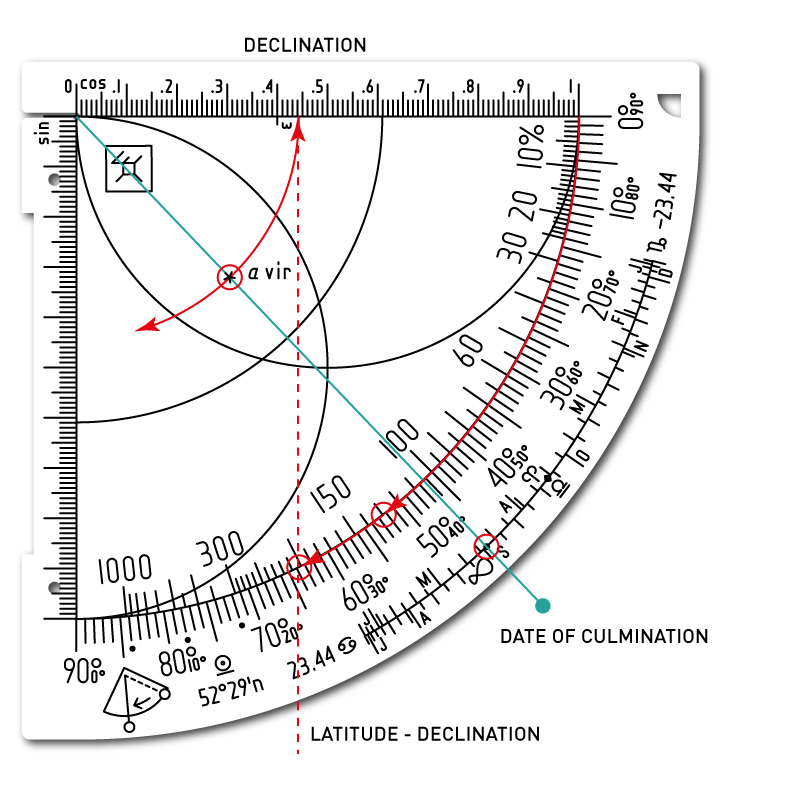
Construction of the star position from declination and date of midnight culmination. Star: SPICA (α Virginis) at -11.3° on APR-13.
Theoretical solution
The practical solution above is of course the application of the cosine method from the Sine Quadrant.[2]
Mathematically, we calculate the distance to the vertex as: cos(latitude - declination) * radius of cosine scale
Thus, for a cosine scale graded in 100ths, the position is 44; for a scale graded in 60ths, the position is 26.5.
How to use the star data
Find the star's altitude on the date of the upper culmination
To calculate the culmination altitude of a star, simply add the declination to the co-latitude:
(90° - latitude) + declination = culmination altitude
To graphically determine the culmination altitude of a star:
- Set the cursor on the star
- Rotate the string to the sine arc
- Read the star's altitude on the degree scale
- Example culmination altitude: 26.2°

Find the star's altitude on the date of the upper culmination. Star: SPICA (α Virginis) at 26.2° on APR-13.
Conversely, from the culmination altitude, we can get the declination
- Set the string on the calendar to the equinox on March 20th and read the altitude of the celestial equator on the degree scale
- In our example: 37.5°
- Subtract this altitude from the culmination altitude for the declination of our star
- Example:
26.2° - 37.5° = -11.3°
- Example:
Measuring elapsed time at night
- For elapsed time, first measure the altitude of a given star
- Then set the cursor for the declination of that star (the same way as for telling time during the day)
- Then input the altitude of the star and find the star time
- Repeat after a while, and find that x hours have passed
To determine the local time at night using the Quadrant, write down the date, the number of days since midnight culmination, the star time correction of 4 minutes per day, and the longitude correction[3] for the location.
What about the Right Ascension?
Right ascension (RA) is the celestial equivalent of longitude. RA can be expressed in degrees, but it is more common to specify it in hours, minutes, and seconds of time: the sky appears to turn 360° in 24 hours, or 15° in one hour. So an hour of RA equals 15° of sky rotation.
Now, we map this over the duration of the whole year. The vernal equinox (1. point in Aries) with RA = 0h is on March 21st -- at noon. Accordingly, the RA of a star tells us what distance it is relative to vernal equinox. RA corresponds to the number of days in which, relative to vernal equinox, this star culminates at noon. Since we are looking for the time of the midnight culmination, an hour angle of 12h (+180°) must be added for these calculations and hence, we start to count the quarters from the (opposite) September equinox (1. point in Libra).
| Q | Season | RA | Dates | |
|---|---|---|---|---|
| 1 | Fall | 0-6h | 0°-90° | SEP-20 to DEC-20 |
| 2 | Winter | 6-12h | 90°-180° | DEC-21 to MAR-22 |
| 3 | Spring | 12-18h | 180°-270° | MAR-23 to JUN-20 |
| 4 | Summer | 18-24h | 270°-360° | JUN-21 to SEP-19 |
On the Quadrant, the star's position along the degree scale corresponds to the Right Ascension (RA) of the star for the respective season, or quarter.
Determining the RA from the data on the Quadrant
The stars on the Quadrant are positioned via declination and date of midnight culmination. By assuming that one degree is about one day,[4] we can derive the RA as follows:
- Determine which quarter the star is in
- Each full quarter is 90° or 6h RA
- Add up the number of full quarters as 6 hours each
- Count the days elapsed in the quarter the star is in
- Divide the number of days by 15 and add the result to the value from 3. above for the approximate RA

Counting quarters and days to find the RA and culmination for α Leonis and α Aquilae.
Example star: REGULUS (α Leonis), culmination at midnight: FEB-22
- α Leonis is in the second quarter (see the label above the star indicating the inner calendar scales), so we note +6h RA for the first quarter
- Days from DEC-22 (start of the second quarter): 62
62 / 15 = 4.13 hours + 6 hours = 10.13 hours = 10h 08mfor the RA- For comparison, the ephemeris lists: 10h 09m 24s
Conversely, we can derive the date of culmination from a given RA
If the RA value is in h:m:s, we convert it to degrees:
- RA° =
(h * 15) + (m / 4) + (s / 240) - Divide the result by 90 for the number of full quarters
- The remainder of the division is the number of days in the star's last quarter
Example star: ALTAIR (α Aquilae), RA: 19h 51m 44s
- α Aquilae is in the fourth quarter (see the label below the star indicating the outer calendar scales)
19h 51m 44s * 15 = (19 * 15) + (51 / 4) + (44 / 240) = 297.93- or:
(19 * 15) + (51 * 15 / 60) + (44 * 15 / 60 / 60)
- or:
297.93 / 90 = 3.31=> 3 full quarters297.93 - 270 = 27.93for the number of days in the star's last quarter- The fourth quarter starts on JUN-23
- JUN-23 + 27 days = JUL-20
- For comparison; the ephemeris lists: JUL-20
Which stars to choose to add to the Quadrant?
The further the observer is from the equator, the lower the celestial equator lies and the lower the stars with negative declinations culminate (northern hemisphere). The closer the observer's latitude is to the equator, the higher the celestial equator is and the higher the stars with positive declination culminate and the more difficult it is to measure the culmination height of such stars.[5]
An approach is to select the brightest stars from the list of navigation stars with declinations between -23.44° and 23.44°. This means that the selected stars peak at altitudes between 16° and 63°. For this reason, the stars should be selected depending on your own latitude.
Choose at least 4 stars, one for each season, one for winter, one for spring, one for summer, and one for fall.
Select stars ...
- at opposite ends of the sky, so at least one will normally be visible,
- that are not circumpolar, so their rising and setting can be used to determine latitude (the equinox hour line is useful for this),
- that are reasonably high over the horizon so they are not obscured by trees and buildings.
Example stars

Example stars added to Latitude Quadrant. Note the positioning of the labels: Above the star refers to the inner calendar scale (JAN-JUN), and below the star refers to the outer calendar scale (JUL-DEC).
| Star name | Decl. | Midnight Culm. | |
|---|---|---|---|
| Gienah | (γ Corvi) | -17.65° | MAR-26 |
| SIRIUS | (α Canis Majoris) | -16.75° | JAN-02 |
| Sabik | (η Ophiuchi) | -15.75° | JUN-09 |
| SPICA | (α Virginis) | -11.3° | APR-13 |
| Mintaka | (δ Orionis) | -0.3° | DEC-14 |
| ALTAIR | (α Aquilae) | 8.9° | JUL-20 |
| REGULUS | (α Leonis) | 11.9° | FEB-22 |
| Markab | (α Pegasi) | 15.32° | SEP-07 |
| ALDEBARAN | (α Tauri) | 16.6° | NOV-30 |
| ARCTURUS | (α Bootis) | 19.1° | APR-26 |
Example stars and their (latitude-independent) data.
Culmination
The culmination date is the date on which a star culminates exactly at midnight local time. This a good reference point to measure the times at night. E.g. the star "Arcturus" (α Bootis) culminates exactly at midnight (0:00 local time, must be corrected for longitude) on April 26th. On April 25th, Arcturus culminates about 4 minutes later (a mean day lasts 23:56:04.0989 hours and therefore exactly 3 minutes and 55.91 seconds shorter than a mean solar day) and about 4 minutes earlier on April 27th. On March 26th, Arcturus culminates about 2 hours later and on May 26th about 2 hours earlier, etc. This means that not only the time distance from the stars, but also the local time of some masses can be determined precisely using the horary arcs of the Quadrant. The 12 o'clock arc during the day is the 0/24 o'clock arc at night.
Culmination is difficult to measure because the altitude of a star doesn't change much around culmination. This can be seen on a Latitude Quadrant where the 11 o'clock and 12 o'clock lines are very close to each other.
(Thanks to Andrej and Erik for their input!)
Resources:
Feel free to use this Excel spreadsheet with the navigational stars and their respective data for your own calculations. Just add your own latitude.
See also:
Footnotes:
- Compare the advanced solution in Twilight Lines ↩
- Why does this work like that? The methods are explained in great detail in the comprehensive book on the Sine Quadrant ↩
- Compare determining Latitude via Compass ↩
- Compare Traversing the Quadrant in The Obliquity Arc ↩
- Longitude correction is explained in the Star Compass tutorial ↩