Wndsn Quadrant Telemeter Tutorials
Making the most out of our graphical telemetry computers.
Like with many complex instruments, there are multiple ways to solve certain problems and to measure the required inputs. Combining the various functions leads to a multitude of advanced uses.
Twilight on the Astronomical Quadrant
The horary lines on the Astronomical Latitude Quadrant show the hours of sunlight, between sunrise and sunset folded over at the noon line, the cosine arc. Sunrise and sunset are represented at the upper edge of the Quadrant alongside the cosine scale.
If we continue calculating the hour lines beyond sunrise and sunset, we have to leave and extend the Quadrant. Or, we fold (and mirror) these lines over and show the additional hour lines inside the Quadrant, alongside the sine scale.
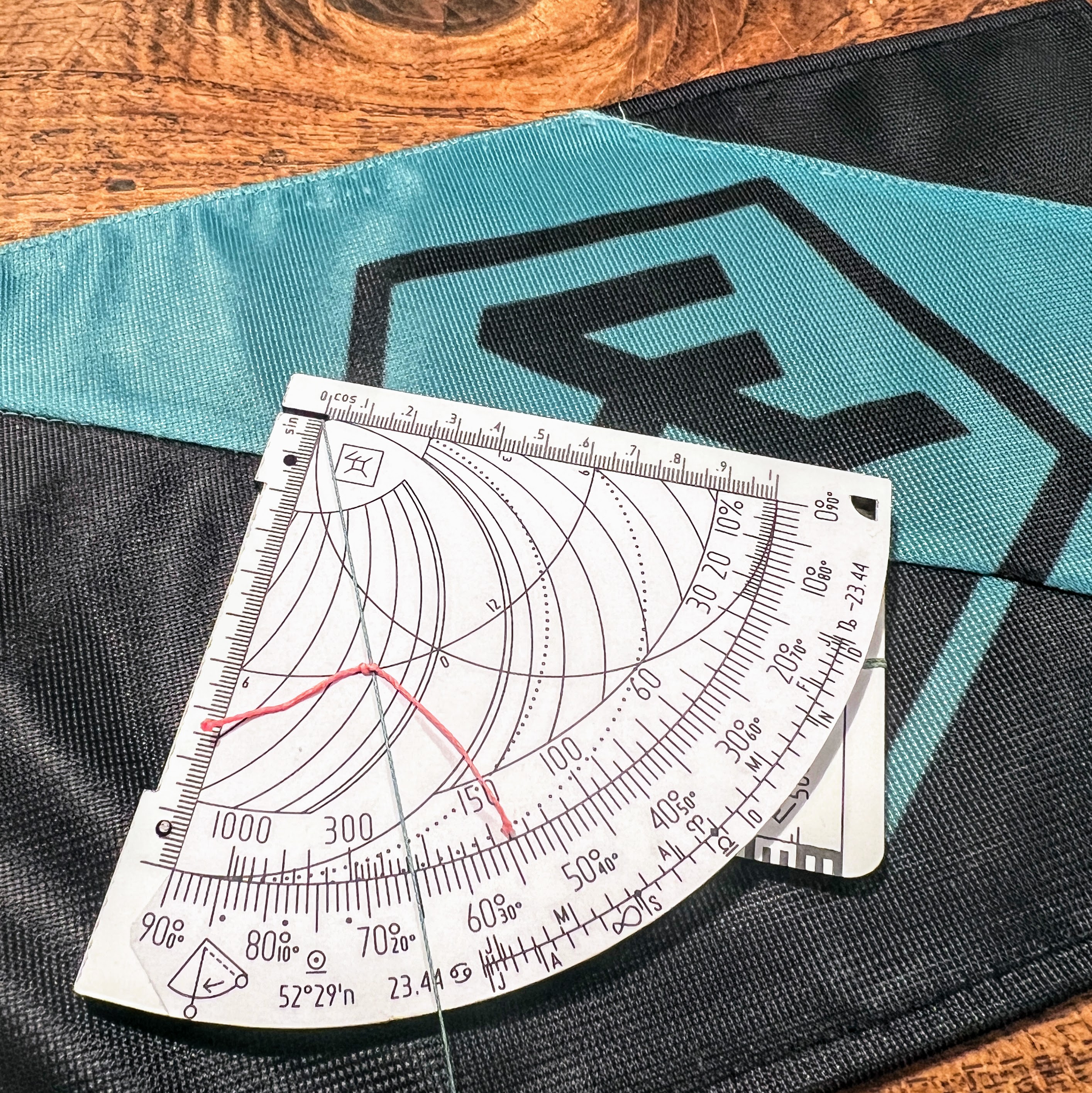
The red knot is on the equinox line (specific to the latitude of this Quadrant). The time shown is either ~3 AM or ~9 PM. Note that we are looking at a negative solar altitude of ~25° here. Further note the dots for the three twilights.

The green string shows the last day (May 16th) and the first day (July 25th) where astronomical twilight ends and the Sun descends beyond -18° below the horizon. Between those days, there is no end to astronomical twilight and thus no night.
Civil twilight is when the Sun descends to altitudes between 0° and -6°; nautical twilight is between -6° and -12°; and astronomical twilight is between -12° and -18°, right after sunset as well as before sunrise.[1]
After astronomical twilight ends, the night begins. "Night" is the term describing the time between two astronomical twilights. In other words, on the days when astronomical twilight does not end, there is no night.
Locations where the Sun remains less than 6 degrees below the horizon -- between 60° 33’ 43” latitude and the polar circle -- experience midnight twilight instead of midnight Sun, so that daytime activities, such as reading, are still possible without artificial light on a clear night. This happens in both Northern Hemisphere summer solstice and Southern Hemisphere summer solstice.[2]
You can see the twilights and compare the above values, as well as the maximum solar depression at midnight using Tycho's Sun Calculator.[3]
Note that twilight at summer solstice is longer than at winter solstice, due to the shape and direction the Sun is moving. The shortest twilight is some time before spring equinox and some time after fall equinox which the Quadrants elegantly represents using the folded-over calendar.
How to read twilight on a regular Latitude Quadrant
Now, an insight into most advanced use cases and features on the Quadrant is that the regular Latitude Quadrant is suitable to solve them in its standard configuration (and the mighty Sine Quadrant can do it all, without modification). So, if you happen to have a custom Latitude Quadrant for your latitude, you can use it to calculate the twilights. Here is how, thanks to superuser Andrej!
By mirroring our date around the equinoxes (or solstices), we can read the negative twilights on the positive solar altitudes of the respective mirror dates.
Example: When is the end of nautical twilight on May 2nd?
Nautical twilight ends when the Sun is at -12° below the horizon. Using the regular Latitude Quadrant, we need to find the mirror date for May 2nd.
How to find the mirror date? By determining how many days the date in question is from the equinox (43 days from March 20th to May 2nd) and then counting that number of days in the opposite direction from the equinox (43 days back from March 20th to February 6th). Alternatively, we can use the declination. May 2nd has a declination of 15.5°, while February 6th has the mirror declination of -15.5°. The declination scale at the top of the Quadrant visualizes this relationship. For how to calculate the declination without the declination scale, recall the methods using the obliquity arc[4] or the ε mark on the various Quadrant models.
To find our answer, we go to February 6th and look up the Sun altitude of 12° which corresponds to the 3rd hour line at the green highlight, or 9 PM (or 3 AM). Compare the hour angle[5] of 44.29° in the table below; 44.29 / 15 ≈ 3 (divide by 15 because 360° / 24 h = 15° per hour).
Advanced solution to find the mirror date
We set the string on the calendar to the equinox on March 20th and read the altitude of the celestial equator on the degree scale; in our example 37.5°. At this position the Sun's declination is 0°. Now we determine the Sun's culmination altitude [h = 90° - φ + δ] on May 2nd; in our example 53°. The distance between the culmination altitude on May 2nd and the altitude of the celestial equator is 53° - 37.5° = 15.5°. To determine the mirror date with a solar declination of -15.5°, we subtract this from the altitude of the celestial equator: 37.5° - 15.5° = 22°. If we set the string at an angle of 22°, we can read February 6th as the mirror date on the calendar.

Compare the colored dots with the color codes in the table to the right. Note how on May 2nd (at a declination of 15.5°), the green highlighted twilight hour angles at -6° and -12° (on the bottom left) match the positive hour angles (count the hour lines) at 6° and 12° (at the top left) on February 6th.
| Latitude φ | 52.50° | ||
|---|---|---|---|
| Declination δ | |||
| Sun altitude h | -15.50° | 0° | 15.50° |
| 18° | 27.35° | 59.49° | 80.48° |
| 12° | 44.29° | 70.03° | 90.40° |
| 6° | 57.34° | 80.11° | 100.56° |
| 0° | 68.81° | 90.00° | 111.19° |
| -6° | 100.56° | 80.11° | 57.34° |
| -12° | 90.40° | 70.03° | 44.29° |
| -18° | 80.48° | 59.49° | 27.35° |
Note the symmetries between the hour angle values for the negative declination and the positive solar altitude as well as the positive declination and the solar depression and vice versa.
References: